SGUK Outdoor Skills Challenge 10: Read a Map
Being able to read a map is one of the most useful skills you can develop for spending time outdoors. A map can tell you far more than where a path goes. It can help you recognise hills, valleys, rivers, woodland, buildings and other features, allowing you to work out where you are and what lies ahead.
In the last challenge, you learned how to pack a day-walk rucksack. For this challenge, you will practise reading a map and matching what you see on paper or on a screen to the landscape around you. You don’t need to be an expert navigator, and you don’t need to travel a long distance. The aim is to slow down, look carefully at the map and start understanding how its symbols and features represent the real world.
Your Challenge
Your task is to read a map of a familiar outdoor area and identify at least five features shown on it. Where possible, compare the map with the landscape around you and see how many of those features you can recognise.
You could use an Ordnance Survey map, another suitable walking map or a printed map of your local area. Choose somewhere safe and accessible, such as a local park, country path or open area where you can look around without putting yourself at risk.
What You’ll Need
- A suitable map of the area you are visiting
- A compass, if you have one
- A pencil and notebook, if you want to record your findings
- Weather-appropriate clothing
- A charged mobile phone for emergencies
Take the Challenge
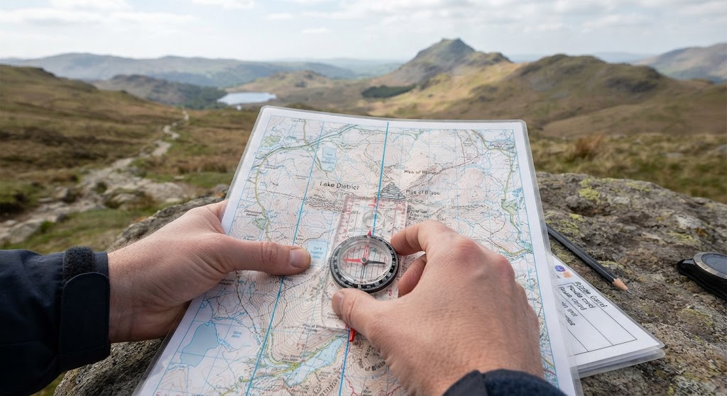
Start by finding your location on the map. Look for recognisable features such as a road junction, a bridge, a building, a stream or the edge of a woodland. If you’re outdoors, compare these features with what you can see around you. If you’re practising at home, use a map of somewhere you know and see how much you can identify.
Next, look at the map symbols. Most maps include a key explaining what different colours, lines and symbols mean. Footpaths may be marked differently from roads, while woodland, water and buildings are often represented using particular colours or symbols. Take a little time to understand the key rather than guessing what each marking means.
Now look at the shape of the land. On a topographic map, contour lines show changes in elevation. Lines close together usually indicate a steeper slope, while lines farther apart generally indicate gentler ground. Contour lines can take practice to understand, so don’t worry if the landscape doesn’t immediately make sense. Try to identify one hill, valley or slope and see how it is represented on your map.
Finally, choose at least five features and identify them on the map. If you’re outside, try to match as many as possible to what you can actually see. If a feature is hidden behind trees or buildings, or is too far away to recognise clearly, choose another one.
Check Your Results
You have completed the main part of the challenge when you can identify at least five features on your map and explain what the symbols or markings represent.
Ask yourself whether you can distinguish paths from roads, recognise water or woodland, and understand what contour lines tell you about the shape of the ground. If you’re outdoors, see how many features you can match confidently between the map and the landscape.
Don’t worry if you make mistakes. Map reading improves with practice, and checking your interpretation against real features is one of the best ways to learn.
Complete the Challenge
Take a photograph of your map-reading practice. You could photograph your map with the features you identified, or take a picture of yourself using the map in a suitable outdoor location. Avoid including sensitive personal information or publishing a detailed route to somewhere private.
How to Submit Your Challenge
- Go to your SGUK member profile.
- Open the Social Activity area.
- Upload your photograph to your activity wall.
- Add the hashtag #SGUKChallenge10.
- Share your post so your evidence can be checked.
Once you’ve shared your evidence and it has been verified, the SGUK Outdoor Skills Challenge 10 is complete and the completed challenges figure will be updated on your profile.
Challenge 10 Checklist
Want to Push Yourself?
Try identifying a hill, valley or other change in elevation using contour lines. If you’re outside, see whether the shape of the land matches what the map suggests.
You could also choose a short route and identify three features you expect to pass along the way before setting off. As you walk, check your progress against the map. Always plan a suitable route, stay on permitted paths where required and turn back or seek help if you become uncertain about your location.
What’s Next?
Reading a map is the foundation of many other navigation skills. As you become more confident, you can combine map reading with compass work, route planning and the use of landmarks to help you find your way outdoors.
Learn. Practise. Master. That’s what the SGUK Outdoor Skills Challenge is all about.
🔒Ready to test your survival skills?
Join Survival Guides UK for free, complete challenges, earn badges and increase your Survival Level.
JOIN FREE →
CRAIG BURR
FOUNDER · SURVIVAL GUIDES UK
I'm Craig, the person behind Survival Guides UK. I created SGUK because I wanted somewhere people could learn real outdoor skills in a practical, straightforward way — from lighting a fire and tying knots to navigation, campcraft and everything in between.
You can read more about the story behind SGUK here as well as our approach here.