OS Map Symbols Cheat Sheet – Free Printable Guide
Whether you’re learning navigation for Scouting, hiking, Duke of Edinburgh’s Award activities, outdoor adventures or simply exploring the countryside, knowing how to read map symbols is an essential skill.
An Ordnance Survey map contains a huge amount of information. Roads, paths, buildings, rivers, woodland, contours, boundaries and other features are represented using symbols and colours, allowing you to understand the landscape before you even set foot on it.
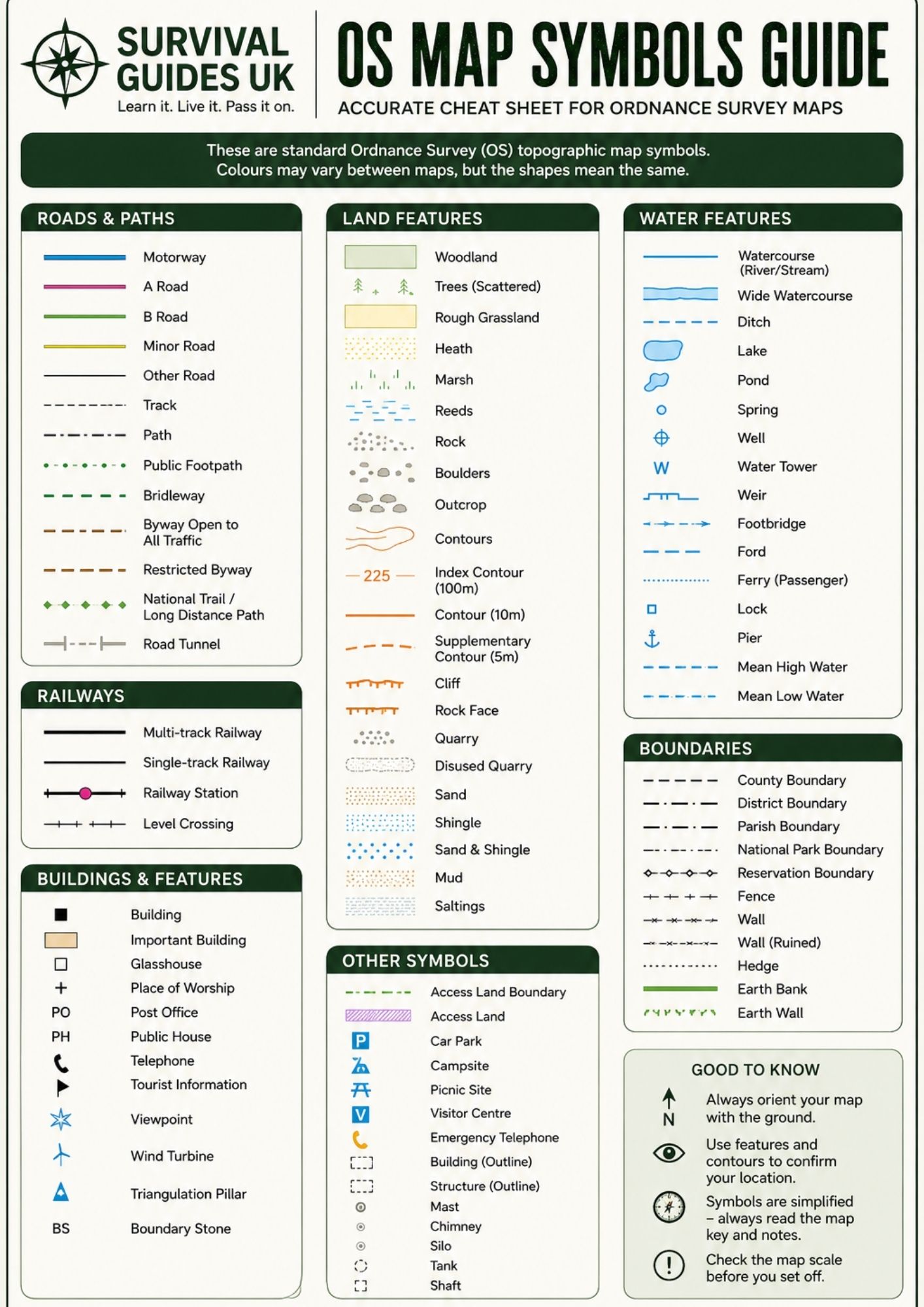
We’ve created this OS map symbols cheat sheet as a quick and easy reference for some of the most commonly encountered symbols on UK topographic maps.
Download the printable OS map symbols guide
Restricted Content
Members Only
Join Survival Guides UK for free to access and download this resource.
JOIN FREE →The guide is designed to be printed and kept with your navigation equipment, Scout activity resources, hiking notes or outdoor skills folder.
For the best results, print it at 100% scale on A4 paper.
What do OS Map Symbols Mean?
Map symbols are a way of representing real-world features on a map without having to draw each feature exactly as it appears on the ground.
Once you become familiar with the common symbols, you can quickly identify useful features and build a picture of the terrain around you.
Our printable guide includes several important groups of symbols.
Roads and paths
Roads and tracks are particularly useful when planning a route or identifying your position.
Depending on the map, you may encounter symbols representing:
Remember that a line on a map doesn’t necessarily mean that the route is suitable for every type of user. Always check the map key and consider the terrain and conditions before setting out.
Contour Lines and Land Features
Contour lines are one of the most important things to understand when reading a topographic map.
They show the height and shape of the land.
Generally:
Contour lines can help you anticipate climbs, descents, ridges, valleys and other changes in terrain.
Learning to read contours is especially useful when planning walks in hilly or mountainous areas.
Water Features
Water is another important part of map reading.
Common symbols can represent features such as:
Water features can be excellent navigation landmarks because they are often easy to recognise both on the map and on the ground.
Buildings and Man-Made Features
Maps also show many different buildings and structures.
Depending on the map, symbols may identify:
These features can provide useful reference points when navigating.
Boundaries, Walls and Fences
Not every line on a map represents a road or path.
Maps can also show different types of boundaries and land divisions, including:
Being able to distinguish these symbols can prevent confusion when you’re trying to interpret the landscape around you.
Why Map Symbols Matter for Navigation
Map symbols become particularly useful when they’re combined with other navigation skills.
For example, you might use:
Map symbols + contour lines + grid references + compass bearings
Together, these allow you to build a much clearer understanding of where you are and where you’re going.
Rather than simply following a line on a map, you can identify features around your route and use them to regularly confirm your position.
A Useful Tip: Always Check the Map Key
Although many symbols are standardised, don’t rely entirely on memory.
Maps can differ in scale, mapping specification and edition, and some symbols can be easy to confuse.
Before navigating, take a moment to check the map legend/key for the particular map you’re using.
The cheat sheet is intended as a convenient reference, but the map itself and its legend should always be treated as the authoritative source for interpreting that map.
Practise Your Map-Reading Skills
The best way to learn map symbols is to use them in the real world.
Take a map of an area you’re familiar with and try to identify:
Once you’re comfortable identifying symbols, start combining them with grid references and compass bearings.
This turns a map from a collection of lines and colours into a useful picture of the landscape.
Download, Print and Learn
Our OS Map Symbols Cheat Sheet is designed as a simple reference that you can print and keep handy while learning navigation.
It’s particularly useful for:
Learn it. Live it. Pass it on.
Important note
This resource is an independent Survival Guides UK educational reference and is not an official Ordnance Survey publication. Map symbols can vary between mapping products and editions, so always consult the legend supplied with the specific map you’re using.
🔒Ready to test your survival skills?
Join Survival Guides UK for free, complete challenges, earn badges and increase your Survival Level.
JOIN FREE →
CRAIG BURR
FOUNDER · SURVIVAL GUIDES UK
I'm Craig, the person behind Survival Guides UK. I created SGUK because I wanted somewhere people could learn real outdoor skills in a practical, straightforward way — from lighting a fire and tying knots to navigation, campcraft and everything in between.
You can read more about the story behind SGUK here as well as our approach here.