Map Reading Guide Printable
Being able to read a map is one of the most useful outdoor skills you can learn.
Whether you’re heading out hiking, taking part in Scouting activities, working towards an outdoor award or simply exploring the countryside, understanding a map can help you plan your route, recognise the terrain around you and navigate with confidence.
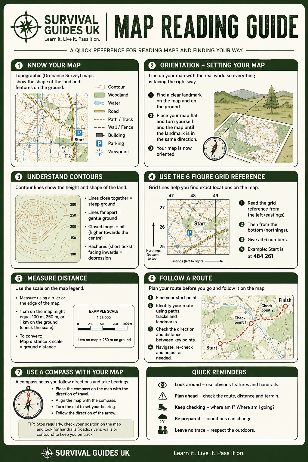
We’ve created this free printable map reading guide as a quick reference for beginners and anyone who wants to refresh their navigation skills.
What’s included?
The guide covers the essential map-reading skills you’ll need outdoors:
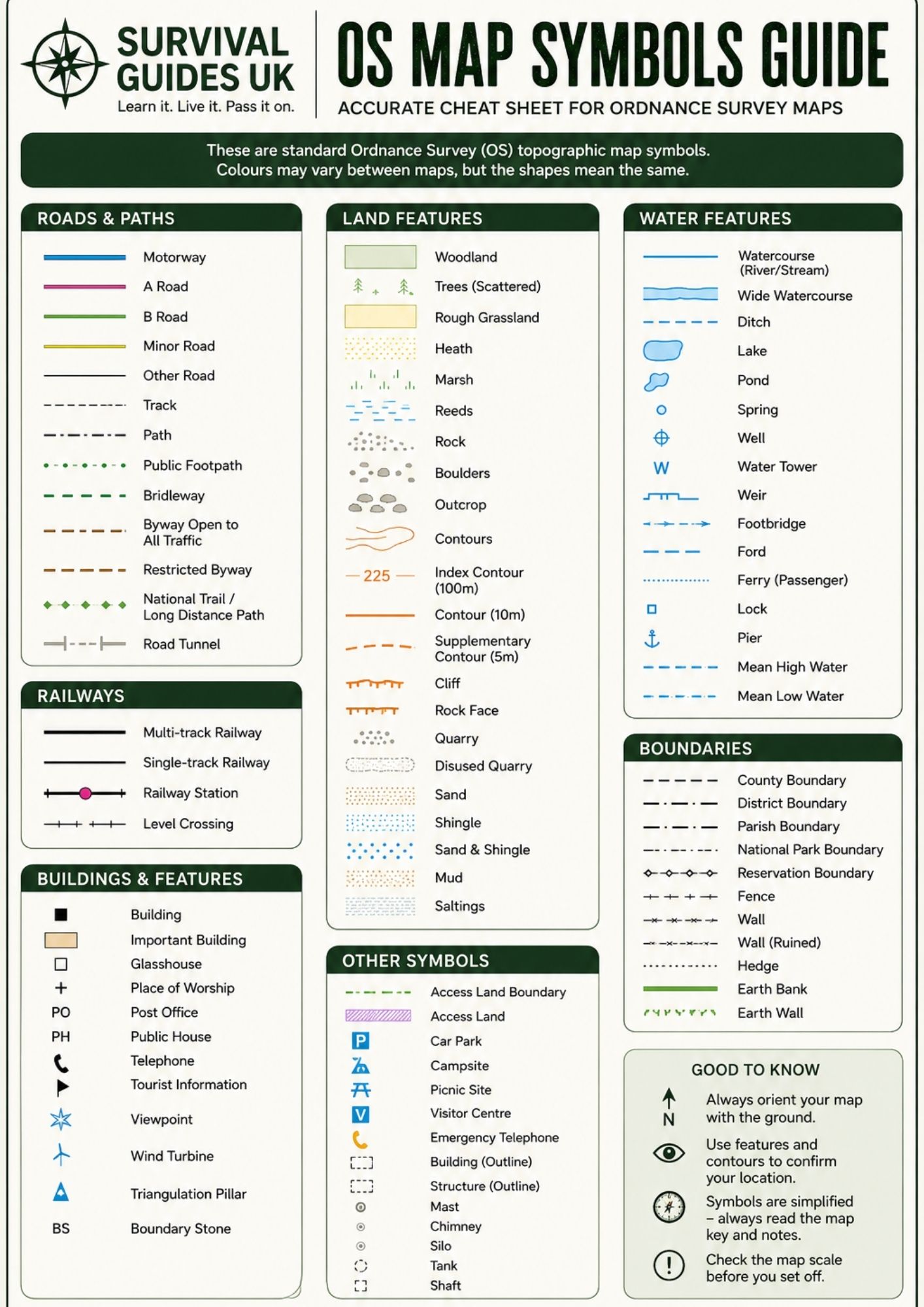
- Map symbols – understand common features shown on a map
- Orienting a map – line your map up with the landscape around you
- Contour lines – understand height, slopes and the shape of the land
- Six-figure grid references – find precise locations on a map
- Measuring distance – use map scales to estimate distances on the ground
- Route planning – identify paths, landmarks and checkpoints
- Using a compass with a map – combine your map and compass skills for navigation
Download the free printable
Restricted Content
Members Only
Join Survival Guides UK for free to access and download this resource.
JOIN FREE →Print it and keep it with your navigation notes, activity folder, hiking kit or Scout resources.
For the best results, print the guide at 100% scale on A4 paper.
Learn map reading step by step
1. Understand your map
Before setting off, take some time to look at the map and identify the features around your route. Roads, paths, buildings, streams, woods and other landmarks can all help you understand where you are.
2. Learn to read contours
Contour lines show the shape and height of the land. Lines close together indicate steeper ground, while lines spaced further apart generally indicate gentler slopes.
Understanding contours is particularly useful when planning routes through hilly or mountainous areas.
3. Master grid references
Grid references allow you to describe an exact location on a map.
A useful rule to remember is:
Along the corridor, then up the stairs.
Read the eastings first, followed by the northings, when taking a six-figure grid reference.
4. Measure your route
The scale printed on your map allows you to estimate the distance you’ll travel. Remember that a route measured as a straight line may be shorter than the actual distance when following paths, roads and the contours of the terrain.
5. Use your compass
A map becomes even more useful when combined with a compass.
Practise orienting your map, taking bearings and identifying landmarks around you. Regularly checking your position helps prevent small navigation errors from becoming bigger problems.
Practise your skills
The best way to become confident with map reading is to practise.
Start somewhere familiar and try to identify features around you from the map. Then gradually move on to planning and following short routes.
Always consider the weather, terrain, daylight and your own experience before heading outdoors.
Learn it. Live it. Pass it on.
More outdoor skills and printable resources are coming soon from Survival Guides UK.
🔒Ready to test your survival skills?
Join Survival Guides UK for free, complete challenges, earn badges and increase your Survival Level.
JOIN FREE →
CRAIG BURR
FOUNDER · SURVIVAL GUIDES UK
I'm Craig, the person behind Survival Guides UK. I created SGUK because I wanted somewhere people could learn real outdoor skills in a practical, straightforward way — from lighting a fire and tying knots to navigation, campcraft and everything in between.
You can read more about the story behind SGUK here as well as our approach here.